
The Cody Wyoming Travel Guide: Things to Do, the Rodeo and the Road to Yellowstone
A working guide to the eastern gateway of Yellowstone: what is here, what is worth your time, and how the valleys fit together.
- Elevation
- 5,016 ft
- Yellowstone East Entrance
- 52 miles
- Rodeo season
- June – August
Cody, Wyoming was laid out in 1896 by a group of investors that included William F. Cody, the showman better known as Buffalo Bill. The town has carried his name, a good deal of his self-mythology, and since 1938 a Cody Rodeo every summer night. It sits on the western edge of the Bighorn Basin at just over five thousand feet, where flat sagebrush country runs up against the Absaroka Range. That position is the whole story of the place: everything east of town is basin, everything west of it climbs.
Most people arrive because Cody is the last town before Yellowstone’s East Entrance, fifty-two miles west. That makes it a staging post, but treating it purely as one is a mistake. The Cody Yellowstone country holds a serious museum complex, a nightly rodeo that has run for generations, a canyon dam that was briefly the tallest in the world, and two of the better mountain drives in the state. A day here is easy to fill; three days is not hard to justify.
What follows is a Cody Wyoming travel itinerary in the loose sense, not a fixed schedule but an account of the things to do within reach of the town and how long each one actually takes. The Cody Yellowstone corridor rewards travel planned around drives instead of opening hours.
How the country fits together
- 1Codythe center of everything · 5,016 ft
- 2Shoshone Canyon3 mi west · ~5 min
- 3Buffalo Bill Dam6 mi west · ~15 min
- 4Wapiti Valley18 mi west · ~25 min
- 5Pahaska Tepee50 mi west · ~1 h
- 6Yellowstone E. Entrance52 mi west · ~1 h 10 · 6,951 ft
- 7Dead Indian Passabout 30 mi north · ~55 min · 8,071 ft
- 8Sunlight Basinabout 35 mi north · ~1 h
- 9Beartooth Passbeyond the byway, on US-212 · 10,947 ft
- 10Powell24 mi north-east · ~30 min
- 11Meeteetse32 mi south-east · ~30 min
- paved main road
- the scenic byway
- shut by snow in winter
- the way out of the mountains
Things to Do in Cody, Wyoming
- Buffalo Bill Center of the West half a day Five museums under one roof, and the reason a wet day here is not a lost one.
- The Cody Nite Rodeo an evening Nightly through the summer at Stampede Park, not once a season.
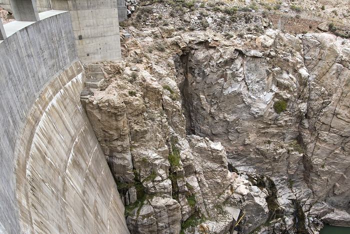
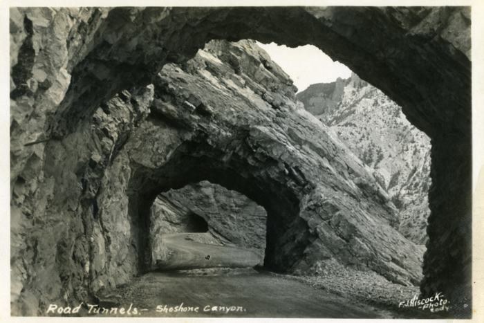
- Buffalo Bill Dam and Shoshone Canyon twenty minutes Six miles west, through three tunnels, with the visitor center built out over the drop.
- Old Trail Town about an hour Original frontier buildings moved here and reassembled, not reproductions.
- The drive west through Wapiti Valley half a day The North Fork road to the park gate, and the reason to leave early.
- Chief Joseph Byway and Sunlight Basin a full day Over Dead Indian Pass at 8,071 ft and down into the basin behind it.
- Fishing the Shoshone half a day or more The North Fork above the reservoir, and the tailwater below the dam.
- Hiking in the Shoshone forest an hour to all day Trailheads run the length of the valley, so the walk fits the day, not the reverse.
The anchor is the Buffalo Bill Center of the West, which is not one museum but five under a single roof: the Buffalo Bill Museum, the Plains Indian Museum, the Whitney Western Art Museum, the Cody Firearms Museum and the Draper Natural History Museum. The scale surprises people who expected a small-town collection. It is the single most substantial indoor attraction between Billings and Jackson, and it is the reason a rainy day in Cody is not a wasted one.
Six miles west, the road to Yellowstone threads through Shoshone Canyon and passes Buffalo Bill Dam. Completed in 1910, it was the tallest dam in the world at the time, wedged into a granite gorge so narrow that the highway has to tunnel through rock to reach it. The visitor center is built out over the drop, and the view straight down is the point. Behind it the water backs up into the valley as Buffalo Bill Reservoir.
Old Trail Town, at the western edge of town, collects original frontier buildings moved here and reassembled. It reads as a preservation project, which is what makes it worth an hour.
The river carries its own half-days. White water rafting on the Shoshone runs through the summer, the quieter Red Canyon trips suit anyone traveling with children, and the outfitters in town run both.
The Cody Rodeo and the Summer Season
Cody calls itself the Rodeo Capital of the World, and the claim rests on frequency, not prize money: the Cody Nite Rodeo runs every night through the summer at Stampede Park, not once a season. That changes what a Cody Rodeo evening is. It is a working local fixture with a running order that moves briskly through bareback riding, calf roping, steer wrestling, saddle bronc, barrel racing and bull riding, with a kids’ calf scramble in the middle that is usually the loudest part of the night.
The Cody Nite Rodeo is the everyday version. The Cody Stampede, held around the Fourth of July, is the big one, and the town fills accordingly. If your dates are flexible and you want the quieter experience, avoid that week; if you want the spectacle, that is the week to aim for. Either way the Cody Rodeo is an evening event, which pairs naturally with a day spent driving one of the valleys.
A first night makes more sense if you know what you are watching. Each event, and the people who make it run, has its own page:
- Barrel racingthe pattern and the clock
- Steer wrestlingbulldogging, start to finish
- Bull ridingeight seconds, and the scoring
- Clowns and bullfightersthe two jobs people confuse
- Pickup menthe riders who collect the broncs
- The stockthe bulls and horses behind the events
- The stock contractorwho supplies a nightly rodeo
- Tack and riggingsaddles, ropes and equipment
- Rodeo termsa glossary for a first night
- Where the events came fromranch work, turned into sport
- Life on the circuittravel, entry fees and earnings
- Rodeo beyond Codythe other arenas in the basin
Planning Your Travel to Cody and Yellowstone
The drive west from Cody to the park gate is the one most visitors make, and it is worth understanding before you set off. It follows the North Fork of the Shoshone River through Wapiti Valley, past eroded volcanic rock formations, and climbs steadily the whole way. Theodore Roosevelt is supposed to have called it the most scenic fifty-two miles in America. Whether or not he did, the road earns the reputation, and it is not a stretch to drive quickly.
- Cody 5,016 ft · mi 0
- Buffalo Bill Reservoir 5,370 ft · mi 6
- Wapiti 5,600 ft · mi 18
- Pahaska Tepee 6,600 ft · mi 50
- East Entrance 6,951 ft · mi 52
North of town, the Chief Joseph Scenic Byway climbs over Dead Indian Pass on a set of switchbacks and drops into Sunlight Basin, crossing the highest bridge in Wyoming on the way. It connects onward to the Beartooth Highway and Red Lodge, Montana. As a loop it is a full day, and in shoulder season the high sections can close without much warning.
| Destination | Miles | Route |
|---|---|---|
| Yellowstone East Entrance | 52 | US-14/16/20, North Fork |
| Powell | 24 | WY-294 / US-14A |
| Meeteetse | 32 | WY-120 south |
| Red Lodge, Montana | 64 | WY-120 / US-212 |
| Billings, Montana | 106 | WY-120 / I-90 |
How many days do you have?
The route planner turns that into an order to do things in, with the real distances and drive times attached.
Where to Stay in Cody
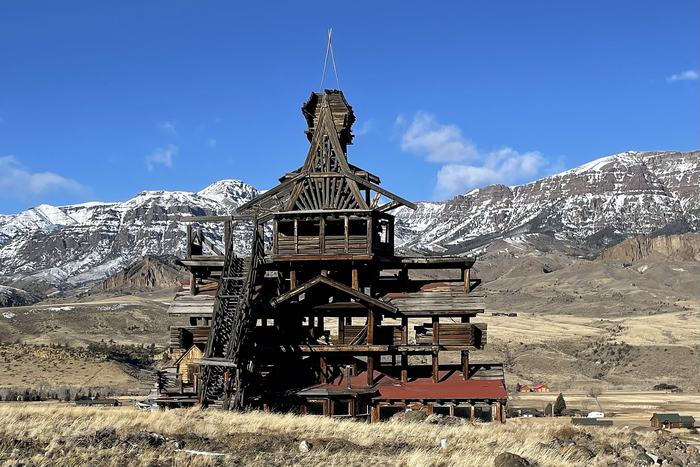
Lodging here splits into four honest categories. The historic hotels sit in the old center, of which the Irma , built by Buffalo Bill in 1902 and named for his daughter, is the landmark. Motels and lodges line the through-roads and the strip toward the rodeo grounds. Guest and dude ranches spread up the North Fork and into the side valleys, and are a different proposition entirely: multi-night, often all-in, usually built around riding. Campgrounds and RV parks run from commercial sites in town out to national forest ground toward the park boundary.
Which one suits depends less on budget than on what you want the days to look like. A ranch up the North Fork puts you closer to the park gate but commits you to the valley. A room in town puts the museum, the rodeo and dinner within walking distance of each other.
How to Use This Cody Wyoming Guide
The pages here are organized the way the country is, not the way a brochure would organize it. Attractions, lodging and food sit together because they are all in town. The valley pages, Wapiti, Sunlight Basin and the North Fork, are separate because each is a drive, and deciding which to give a day to is the real planning question on any Cody Wyoming trip.
Opening times, prices and schedules are deliberately not listed. What is here instead is the part that does not change: where things are, how far apart, how long they take, and whether they are worth the drive. Read this Cody Wyoming guide as a map of the ground, not a timetable.
The errands a road trip generates, fuel before the valleys, a car wash after them, laundry between them, are on the practical stops page, and where to eat is on its own.
Common questions
How far is Cody from Yellowstone?
The Yellowstone East Entrance is 52 miles west of Cody on US-14/16/20, following the North Fork of the Shoshone River through Wapiti Valley. It is a slow, scenic road, and the climb gains roughly 1,900 feet along the way.
How many days do you need in Cody, Wyoming?
Two days covers the town itself and one of the valleys: the museum complex and the rodeo on one day, the drive west or the drive north on the other. Three days lets you take both mountain roads without folding them together, which is the mistake most itineraries make. One day is enough only if you treat Cody as a stop instead of a base.
What elevation is Cody, Wyoming?
5,016 feet, down on the basin floor. The ground rises steadily west of town toward the Absaroka Range, which is why the drive to the park gate feels like a continuous climb.
When does the Cody Nite Rodeo run?
Every night from roughly the start of June to the end of August, at Stampede Park just west of the center. Season dates and start times are set year by year, so check the current ones first.
What is the difference between the Cody Nite Rodeo and the Cody Stampede?
The Nite Rodeo is the everyday version, run night after night through the summer, and you can generally walk up to it. The Stampede is the annual event held around the Fourth of July, on a different scale entirely, and it fills the town. They are worth treating as two separate decisions when you pick your dates.
Can you drive from Cody into Yellowstone in winter?
Not on the East Entrance road. It closes to ordinary vehicles for the winter and reopens in spring, and the high sections of the Chief Joseph Scenic Byway and the Beartooth Highway close as well. Snow decides the calendar, not the date, so the useful question in shoulder season is what is open this week, not this month.
Is Cody worth staying in, or just passing through?
Staying wins here. There is a full day inside the Buffalo Bill Center of the West, an evening in the arena, and a half-day drive in each of the two directions out of town. Passing through buys you one of those four.
What is there to do in Cody besides the rodeo?
The five museums of the Buffalo Bill Center of the West, Buffalo Bill Dam and its visitor center above Shoshone Canyon, Old Trail Town, fishing and rafting on the Shoshone, and the scenic drives north into Sunlight Basin and west into Wapiti Valley.