Sunlight Basin Wyoming: the Chief Joseph Scenic Drive, Cody's Elevation and the Map
Published
- Cody 5,016 ft · mi 0
- WY-296 turn 5,600 ft · mi 17
- Dead Indian Pass 8,071 ft · mi 30
- Sunlight Creek 6,400 ft · mi 38
- Sunlight Basin 6,600 ft · mi 46
Most visitors to Cody drive west. The road north is the one that rewards the people who look at the map properly. Sunlight Basin Wyoming, reached over Dead Indian Pass on the Chief Joseph Scenic Byway, is the better scenic drive of the two, and it goes almost nowhere that anybody needs to be.
Cody WY elevation, and why it matters on this scenic drive
The Cody WY elevation is 5,016 feet, and the number is worth holding on to, because everything about the country around the town gets described relative to it. East is the Bighorn Basin, flatter and drier and lower. West the ground climbs steadily to the Yellowstone plateau. North, it climbs very fast indeed.
The figure that matters on this drive is the pass, three thousand feet above the town. Arriving from lower country, some people feel the altitude in Cody itself and almost everyone feels it at the top of Dead Indian. The consequences are ordinary, a little breathlessness, faster dehydration, strong sun, but they arrive sooner than people expect, and the Cody WY elevation down on the valley floor gives no warning of them.
The Chief Joseph scenic drive, on the map
The route is Wyoming State Highway 296, leaving the Belfry road north-west of town. For the first stretch it is unremarkable ranch country. Then it begins to climb, and the character changes completely.
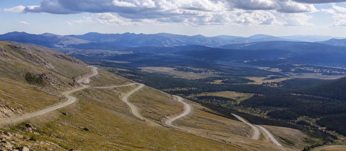
The climb to Dead Indian Pass is a set of long switchbacks up an open face, and it is the part of the drive that everyone photographs. At the top, 8,071 feet up, there is a pull-off, and it is the single best stop on the route: the view looks back down the switchbacks you have just driven and out over the basin country beyond, with the Absarokas standing up to the south.
Over the top the road drops into Sunlight Basin Wyoming itself, a broad, high, quiet valley that feels a long way from anywhere despite sitting an hour from a town with five museums in it.
Sunlight Creek Wyoming and the highest bridge in the state
On the far side of the pass the byway crosses the gorge cut by Sunlight Creek Wyoming, on the highest bridge in the state. There is parking at the end of it and a short walk onto the deck.
The gorge is narrow and the drop is considerable, and unlike a great many things called scenic, this one delivers immediately. You look over the rail and the creek is a very long way down. It takes ten minutes and it is the second reason to make the drive. Sunlight Creek Wyoming is a modest stream with a spectacular trench, and it gives the basin both its name and its one piece of engineering.
Sunlight Basin Wyoming on the map: where the scenic drive goes
The byway continues north-west and meets the Beartooth Highway, which climbs to Beartooth Pass at 10,947 feet before dropping into Red Lodge, Montana. Taken as a loop, out over Dead Indian, up the Beartooth and back down through Belfry, it is a long spectacular day and one of the better drives in the region.
Taken there-and-back from Cody, this scenic drive is a comfortable half day, which is how most visitors should treat it. The pass and the bridge are the two things worth the trip and both sit on the near half of the route.
Seasons and closures
None of this is year-round. The high sections close with snow, and the closure is decided by conditions, not by a published date, so late spring and early autumn are both uncertain. The Beartooth beyond has a shorter season still and is often shut when the byway is open. Sunlight Basin Wyoming is not on the way to anywhere, and a road carrying no through traffic is not one anybody hurries to reopen.
Afternoon storms build over the high country through the summer with very little warning, and on an exposed switchback face there is nowhere to be during one. Morning is the better half of the day for this drive, which happens to be when the light on the pass is best anyway.
One drive per day
West to the park through Wapiti Valley and north over Dead Indian Pass share only a starting point, and folding them into one day is the most common planning mistake made in Cody.
The two profiles make the case better than any argument. The road west to Yellowstone gains 1,900 feet spread over 52 miles. This one gains 3,000, with most of that in the final thirteen.
Cody sits at 5,016 feet. Dead Indian Pass on the Chief Joseph Scenic Byway tops out at 8,071 feet, about 30 miles north-west, a gain of roughly 3,000 feet. Almost none of it happens early. The road runs ranch country barely above the town for the first seventeen miles, reaching only about 5,600 feet at the WY-296 turn, and then climbs some 2,400 feet in the final thirteen. That is a materially steeper profile than the 1,900 feet spread over 52 miles on the Yellowstone road west, and it is the clearest single reason the two drives are separate days.
Common questions
What elevation is Cody, Wyoming?
About 5,016 feet above sea level, on the floor of the Bighorn Basin. That figure is the baseline for everything around it: the country climbs in every direction except east, and the passes north and west of town are three thousand feet higher again.
Where is Sunlight Basin?
North-west of Cody, reached over Dead Indian Pass on the Chief Joseph Scenic Byway, Wyoming State Highway 296. It is a broad high valley on the far side of the pass, drained by Sunlight Creek.
What is the highest bridge in Wyoming?
The Sunlight Creek bridge, on the Chief Joseph Scenic Byway, crossing the gorge that Sunlight Creek has cut. There is parking at the end of it, and the view down from the rail is the reason people stop.
Is the Chief Joseph Scenic Byway open all year?
No. The high sections close with snow, and the timing varies year to year instead of following a fixed date. The Beartooth Highway it connects to has an even shorter season.